The best Scenic Spots & Sunset Locations on the Main Island
Everyone's seen the same Okinawa photos: Kabira Bay from the glass-bottom boat, Cape Manzamo at golden hour, or the obligatory turquoise-water shot from Kouri Bridge. They're beautiful, but they're everywhere.
If you're a photographer who's tired of replicating the same postcards, this guide to Okinawa's best hidden photo spots is for you. Discover the best photography locations that haven't been overexposed yet.
Okinawa has a completely different side, one made of sheer jungle cliffs, wind-scraped sacred islands, lunar-tide sandbars, and waterfall pools that feel genuinely untouched. These are the places that still surprise you, from the Okinawa main island's remote north all the way to the Yaeyama chain.
What to Expect:
- Legwork: Some spots require hiking or wading.
- Permits: A few locations have new access rules for 2026.
- Timing: Early mornings or specific tides are often required.
- Etiquette: Respecting local culture is paramount to keeping these spots open.
This article covers eight genuinely hidden gem photo spots across the main island, the Kerama Islands, Miyako, and the Yaeyama Islands. It also includes the drone regulations you actually need to know and a month-by-month photography calendar for your Okinawa trip.
8 Hidden Photo Spots in Okinawa Worth the Effort
1. Kayauchi Banta : The Cliff Nobody Falls Off | Cape Hedo Natural Wonders & Sunset Spots
Where: Gima, Kunigami Village, northern Yanbaru. About five minutes north of the Cape Hedo turnoff on Route 58. Coordinates: 26.8755°N, 128.2538°E.
The name translates to "thatching-grass cliff," which comes from a local tradition of tossing bundles of kaya grass over the edge to test the updraft. The cliff drops roughly 80 meters straight into the East China Sea, and on a clear afternoon, the panoramic view stretches south all the way to the Motobu Peninsula.
What makes it genuinely photogenic, rather than just dramatic, is the combination of elements: the reef pattern below, the forested mountains behind you, and a long arc of coastline that doesn't look like anywhere else in Japan. The stunning views from the edge are among the best natural wonders of Okinawa prefecture's main island.
- Best light: Late afternoon to sunset. The cliff faces west, so you get the full golden-hour treatment from around 16:00 in winter and 18:30 in summer. This is one of the best sunset spots in the area, the emerald and deep blue sea below catches the last light beautifully. Midday flattens everything out.
- Best season: October through April. Autumn and winter air in Yanbaru is noticeably cleaner, and the reef pattern below is sharper when swell is higher.
- Access: Free roadside parking. There's a well-maintained wheelchair-accessible viewpoint. No fence at the cliff edge, be careful with tripods while you take photos.
2. ASMUI Spiritual Hikes (Daisekirinzan) : The Karst Cathedral | Yaedake & Observation Deck Views
Where: 1241 Ginama, Kunigami Village. Coordinates: 26.8614°N, 128.2545°E. Five minutes by car from Cape Hedo.
This is Okinawa's northernmost tropical karst — 250-million-year-old limestone formations that have been worn into enormous, jagged pillars by millions of years of erosion. Before it was a hiking park, this was Ashimui, sacred ground said to be the first place designated by Amamikiyo, the Ryukyuan creator deity. There are more than 50 active prayer sites still in use throughout the park.
For photographers, the headline composition is the Spectacular View Trail: ancient banyan trees arching over narrow paths between limestone walls, the Ugangajumaru (the park's enormous central banyan), and the light that hits the forest floor in broken shafts for the first two hours after opening. A hilltop observation deck near the summit trail offers 360-degree panoramic views over the Okinawa main island's forested northern coastline that captivate every visitor who makes it up here.
- Best light: First two hours after the 9:00 opening, before 11:00. The low angle sends light through the gaps in the canopy and illuminates the karst textures beautifully.
- Best season: Late October through February. Cool weather, low humidity, sharp detail. If you time it right, you can combine this with the kanhizakura cherry blossoms on Yaedake, 30 minutes south, in late January, one of the most beautiful natural wonders in Okinawa prefecture.
- Access: Admission ¥1,200. Hours vary by season (9:00–17:30 in winter; 9:00–18:00 in summer). Free parking, shuttle bus to the trailhead. Stay on marked paths, the limestone is an active sacred site, not just scenery.
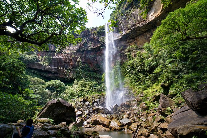
3. Ta-taki Falls: The Waterfall You Earn
Where: Trailhead at 1570-1 Tsuha, Ogimi Village. From Route 58, about 6.9 km north of the Kouri Island intersection. Cross Henan Bridge, turn right immediately, then drive 2.7 km inland past a fish hatchery.
Ta-taki is not the kind of waterfall you drive up to. The photo is the journey, and the journey is a 30 to 45-minute river scramble through the Henan River. Knee-deep wading, boulders with ropes, canyon light slicing through the jungle canopy. At the end, a roughly 10-meter horsetail fall drops into a circular pool with a rope swing. This is a genuine hidden gem for Okinawa sightseeing, the kind of beautiful natural spot that never ends up on a standard tourist spots map.
The compositions available here are largely absent from the standard Okinawa photography playbook, because most people either don't know about it or aren't willing to get their feet wet. It is a highly recommended trek for those seeking natural beauty.
- Best light: Overcast mornings. Direct sun blows out wet rock and creates distracting highlights. Soft, diffused light saturates the moss and makes the water glow.
- Best season: Late October through April, when flash-flood risk is lower. Do not enter if it has rained in the previous 24 hours — the river can rise quickly.
- Access: Free. Water-appropriate shoes are essential (flip-flops will fail). Bring a dry bag for your camera. The round trip is about 5 km.
4. Cape Kaberu, Kudaka Island : Sacred Light at the Edge of Japan | Remote Island Hidden Gem
Where: Northeast tip of Kudaka Island. The ferry runs from Azama Port, Nanjo City, about 15 minutes on the high-speed boat, 25 on the regular ferry. Three departures per direction daily.
Kudaka is called the "Island of the Gods." It's the mythological landing point of Amamikiyo, and many Okinawan people consider it the most spiritually important island in the entire Ryukyu chain. Cape Kaberu, at the northeast tip, is a nationally designated natural treasure, a wind-pruned coastal shrubland unlike anything on the main island, facing northeast over open ocean. This remote island is one of the most captivating and beautiful places in Okinawa for photographers who want something genuinely different.
The photography angle is unique in Okinawa: this is one of the only places where you get a sea-sunrise composition, with low subtropical grasses as foreground and nothing but horizon ahead. The approach trail, framing turquoise water between windswept vegetation, is quietly spectacular.
- Best light: Sunrise, before the 09:30 ferry delivers day-trippers.
- Best season: February through April. Calm seas, reliable ferries, comfortable walking temperature.
- Access: Bicycle rental at the port, about ¥1,000 per day. Sacred rules apply and are strictly observed: removal of sand, shells, stones, plants, or coral is prohibited. Several utaki are completely off-limits to outsiders. The beach at the cape is sacred, swimming is not allowed. Some signs forbid photography; follow them.
5. The Rock Window Below Cape Maeda : Okinawa's Secret Frame
Where: Below 712-2 Maeda, Onna Village. Descend via the steep stairs on the southern flank of Cape Maeda, past the Blue Cave parking and dive shops.
Cape Maeda is packed. Everyone goes there for the Blue Cave, which is worth seeing but visually exhausted. What almost nobody finds is the natural rock arch on the cliff face below, a window in the limestone that perfectly frames the East China Sea and the blue sea beyond.
Shooting up through the rock window gives you a foreground-framed ocean composition that simply doesn't exist anywhere else on the main island. Japanese wedding photographers have been using it for years. International photographers mostly haven't found it yet. It's one of those hidden gem photo spots in Okinawa that rewards the people willing to walk past the crowds.
- Best light: Late afternoon. West-facing, so you get the full benefit of golden hour — and if you time it right, you can watch the sunset frame perfectly through the arch.
- Best season: April through early June, and October through November, when surf is calmer. Avoid typhoon swell season.
- Access: Pay parking at Cape Maeda. The stairs are steep and slippery, not ideal with heavy gear on a busy weekend.
6. 17END, Shimojishima : Where the Runway Meets the Reef | Miyako & Naha Connections
Where: Northwest end of Shimojishima Airport's runway 17. Shimojishima connects to Irabu Island, which connects to Miyako via the 3,540-meter Irabu Ohashi Bridge. Rough coordinates: 24.823°N, 125.137°E.
The name is literal, the end of runway 17. At low tide, a turquoise reef flat sandbar appears in front of the airport's approach lighting catwalk stretching out over the water. Small aircraft come in just overhead. The scale, the color, and the juxtaposition of aviation infrastructure against one of the clearest emerald waters on earth creates an image that doesn't look like anything else. This is one of the most instagrammable spots on Miyako, and almost no one outside of Okinawa prefecture knows it exists.
The Karumata parking area at the foot of Ikema Bridge, overlooked by basically every Miyako guidebook, also offers what might be the best bridge-and-sea composition in the entire prefecture, with spectacular views over the surrounding reef.
- Best light: Sunset for the runway and bridge composition. Morning for sand texture with side light.
- Best season: April through June for the most vivid water color. Weekday mornings to avoid parking chaos.
- Access: Free roadside parking. The sandbar only appears at low tide, check Miyakojima tide tables before making the 40-minute drive from Hirara. Important: drone flight near the runway is prohibited. Shimoji is an active aerodrome. From Naha, fly to Miyako Airport (MMY), about 55 minutes, then rent a car for the drive to Shimojishima; renting a car is the only practical way to reach 17END independently.
7. Aharen Beach Observatory, Tokashiki Island : The Other Kerama View | Sunset Spots & Scenic Views
Where: Aharen, Tokashiki Island. High-speed ferry from Naha Tomari Port takes about 35 minutes; the regular ferry takes around 70. Tomari Port is a 10-minute walk from Miebashi Station on the Yui Rail.
Most people who sightsee the Kerama Islands go to Zamami and Furuzamami Beach. Which is beautiful, but heavily photographed. Tokashiki Island's Aharen Beach is less visited, and its hilltop observation deck, framing the bay between two headlands with uninhabited Hanari islets stacked in the background — gives you a composition that Furuzamami simply can't match at sunset. The panoramic vistas from up here, with the deep blue sea stretching to the horizon, are among the most spectacular ocean views anywhere in Okinawa.
The bay faces west, which means you get the full golden hour over "Kerama Blue" water. The color is real: underwater visibility averages around 30 meters and peaks above 50 meters on clear summer days.
- Best light: Last hour before sunset and the 30 minutes of blue hour that follow. This is one of the best sunset spots in the Kerama Islands — the beautiful sunsets here are magnificent scenery by any standard.
- Best season: April through October for the water; December through March for the bonus of humpback whales visible from shore near Zamami.
- Access: Ferry reservations are strongly recommended in summer. The entire Kerama archipelago is Keramashoto National Park — swimming is only permitted in designated areas. Pack out everything you bring in.
8. The Top of Pinaisara Falls, Iriomote: The Edge of the World | Natural Wonders of the Remote Islands
Where: Upper Hinai River, Taketomi Town, Iriomote Island. Access requires about 30 minutes of kayaking through mangrove forest followed by a 45–60 minute jungle hike.
Pinaisara is Okinawa's tallest waterfall, the water drops roughly 55 meters into the basin below. From the lip, you look out over Japan's largest mangrove forest, with Hatoma, Barasu, and Hatobanare islands floating offshore in the East China Sea. There is no photo taken in the prefecture that looks like this one. It's the kind of natural wonder that makes an Okinawa trip feel genuinely unforgettable.
Important update for 2026: As of March 2025, Taketomi Town implemented a daily entry-restriction and advance permit system for Pinaisara. You must book through a licensed tour operator, who handles the permit filing. A ¥500 per-person access fee is included in tour pricing. Independent hiking to the top is no longer practically available for foreign visitors.
- Best light: Mid-morning at the top (sun behind you, lighting the mangrove carpet below); late afternoon at the base (mist catches the western light).
- Best season: November through March. Cool weather, full flow after winter rain. Avoid May through June (leeches, mud), and July through September (typhoon risk, frequent ferry cancellations). The best time to visit is November through early February, when the weather is cool and the falls are running strong.
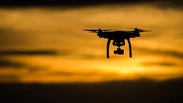
Drone Regulations in Okinawa: What You Actually Need to Know
Most travel photography articles say something like "check local regulations before flying." That's not enough. Okinawa has three overlapping layers of drone law, and getting any of them wrong can mean fines up to ¥500,000, confiscation, or worse.
Layer 1: National baseline (MLIT, Civil Aeronautics Act)
All drones weighing 100 grams or more must be registered through DIPS 2.0. Registration fees run ¥900 to ¥1,450 depending on ID verification method; passport-based online verification is the practical route for foreign visitors. Drones registered after June 2022 must broadcast Remote ID. Standard flights must stay below 150 meters, remain within visual line of sight, and stay 30 meters from people and structures. Permit applications go through DIPS 2.0 and require at least 10 business days lead time. Start this process at minimum two weeks before your trip to Okinawa.
Layer 2: The 300-meter military exclusion zone
This is where Okinawa is completely different from the rest of Japan. The Ministry of Defense's Drone Act prohibits flights within approximately 300 meters of designated U.S. Forces Japan and JSDF facilities without explicit written consent. Confirmed designated facilities in Okinawa include Kadena Air Base, Camp Schwab, Camp Hansen, Camp Foster, and Camp Naha. Torii Station and MCAS Futenma operate under the same regime. If you're anywhere in central or northern Okinawa, check the live MOD designated-facility list before you launch.
Layer 3: National parks
There's no blanket drone ban in Japan's national parks, but flying in Special Protection Zones under the Natural Parks Act is effectively prohibited. In practice, consult the Okinawa Amami Nature Conservation Office before flying anywhere in Yambaru, Iriomote-Ishigaki, or Keramashoto national parks. Use the MLIT geospatial no-fly map for a better view of restricted zones near Naha Airport or Miyako Airport.
Cultural Etiquette and Conservation: The Stuff That Actually Matters
Utaki : Sacred sites that are not Instagram backgrounds
An utaki is not a shrine in the conventional sense. It's a natural space — a grove, a rock, a spring — where Ryukyuan deities and ancestors are believed to be present. There are hundreds across the islands, many unmarked on places in Okinawa maps. The rules are not optional. A rope barrier, a length of bingata cloth tied to a tree, a small stone altar, or a ceramic incense vessel means "this is a prayer site." Lower your voice. Don't photograph. Don't step inside.
Coral, red soil, and what overtourism actually does
Okinawa has lost enormous areas of coral cover since the 1970s. Red soil is a specific Okinawa problem. Tropical rains wash the characteristic rust-colored clay from disturbed ground into the rivers and then the sea, where it smothers coral.
Practical actions:
- Stay on marked trails, especially in the northern forests.
- Never stand on or anchor gear in living coral.
- Use reef-safe sunscreen near water.
- Don't remove shells, sand, coral, or stones from any beach, this is prohibited by law on Kudaka and expected everywhere else.
Geotagging ethics
Okinawa surpassed Hawaii in annual tourist arrivals back in 2017. The pressure on fragile, unmarked sites is real. When a hidden gem with no toilets, no bins, and no lifeguards gets geotagged into viral status, the result isn't tourism, it's degradation. Many of the most beautiful places in Okinawa have been significantly damaged this way. Consider this when planning your next social media post.
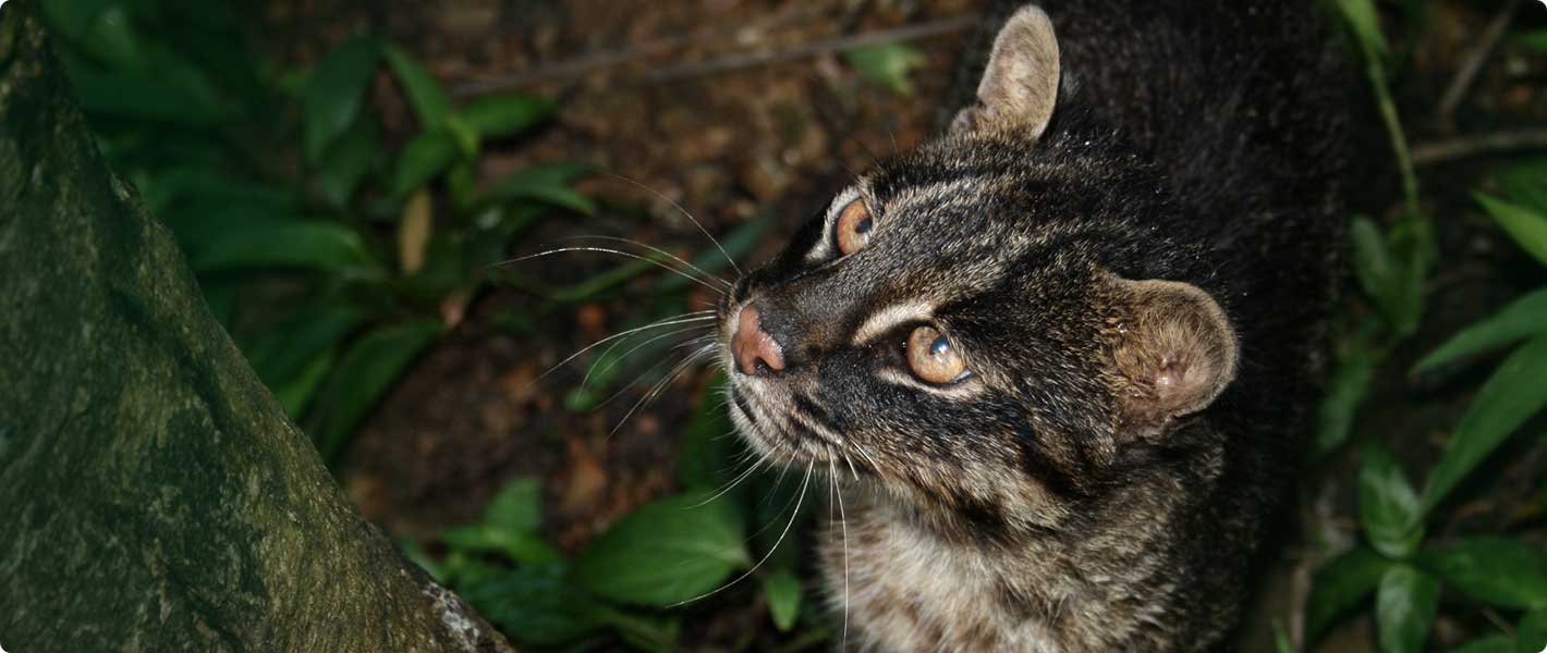
The Iriomote cat
Iriomote Island has a population of approximately 100 of these critically endangered wild cats. The primary cause of population decline is vehicle strikes. If you're driving on Iriomote at dusk or dawn, drive slowly. The same applies to forest roads in Yanbaru for the Okinawa rail.
FAQ
What are the most underrated photo spots in Okinawa?
The most genuinely underrated photography locations for photographers are Kayauchi Banta in northern Yanbaru (an 80-meter cliff with reef views and stunning views of the East China Sea that almost no international visitors reach), Ta-taki Falls in Ogimi (a river-scramble waterfall with exceptional jungle compositions), and the 17END beach on Shimojishima near Miyako (a reef flat beside an active airport runway, only visible at low tide).
Can you use a drone for photography in Okinawa?
Yes, but you need to register your drone through Japan's MLIT DIPS 2.0 portal before arriving. In Okinawa specifically, a second layer of regulation prohibits flight within 300 meters of designated U.S. Forces Japan facilities, which covers large areas of central and northern Okinawa including Kadena Air Base, Camp Schwab, Camp Hansen, and Camp Foster. National parks add a third layer requiring prior consultation with the Okinawa Amami Nature Conservation Office. Flying near any active runway (including Shimoji on Miyako) is also restricted.
Are there hidden beaches in Okinawa that tourists don't know about?
Yes. Toma Beach on Zamami Island is officially designated as a non-swimming area, which keeps the crowds at Furuzamami and Ama Beach instead. The beach below Cape Maeda (past the Blue Cave crowds) has a natural rock arch that most international visitors never find. Several coves on Kudaka Island are genuinely untouched hidden gems, though they're within a sacred landscape where specific access rules apply. Miyagi Island and Kouri Island also have small, lesser-known beach pockets that reward those who take the time to explore on foot and stroll away from the popular spot.
Is it safe to geotag Okinawa photo locations on Instagram?
For well-known locations in Okinawa with established infrastructure, yes. For remote beaches, forest trails, and inland waterfalls with no facilities, the responsible answer is no. Okinawa's coral reefs and fragile ecosystems can't absorb sudden mass visitation. The rule of thumb: if there are no toilets and no bins, don't geotag. Share the image without the location, or describe it only in general regional terms.
How do I get to the remote islands of Okinawa for photography?
Ferries run from Naha's Tomari Port to the Kerama Islands (35–70 minutes to Tokashiki Island), and from Naha Airport to Miyako and Ishigaki by domestic flight (45–60 minutes). Iriomote is reached by ferry from Ishigaki Port (35–50 minutes). Book ferries in advance during Golden Week (late April) and the summer peak season. In typhoon season (July–September), build at least one contingency day into any outer-island itinerary, ferries cancel on short notice. If you have time, stop by a local cafe in Yomitan or Naha to ask a local guide for more recommended spots.
Evertrail Tours · May 12, 2026